MapPad GPS Land Surveys
- 安卓
- 8小时前
- ⏳ 已提交(10-24 09:09)
- 2 ℃
- 0 评论
摘要
 使用地图或GPS测量距离和面积 - 分享你的成果最简单的方式...
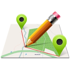
MapPad
海沙工作室
备案号:待更新
 安卓
安卓《MapPad》游戏 APP 是海沙工作室开发的安卓系统应用软件,版本号:6.5.2,由丢塔游戏网整理,欢迎下载体验。
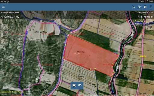
Use MapPad to calculate areas, perimeters and distances - save, export and share your measurements. \\r
MapPad is providing multi-purpose mapping solution allowing location capture and determines distance and area for the shapes drawn on the map or captured using real-time GPS tracking. \\r
Calculate area of the field or a walk distance instantly using Google or Bing Map Satellite view. Save petrol and time and capture features with few clicks on the map. \\r
Area & Distance measurements are very accurate - please compare with other apps and what\'s on the ground. \\r
With MapPad you can capture, manage and share your data easily. App supports number of well-known cloud providers like G-Drive, Dropbox, Google Fusion Tables and export formats: KML, GPX, CSV and AutoCAD DXF. \\r
MapPad is a very useful tool for anyone involved in forestry, agriculture (measuring farms, soils, grow, check planted area etc.), roofing, solar panel planning and solar panel installation, fencing, construction, real estate management, asset management, winter snow removal or farming business.\\r
MapPad also can be used in the whole range of outdoor activities like golf (distance meter and range finder), biking, walking, running, jogging and other sports where possibility of measure areas or distances is necessary.\\r
Please visit our website to find out how to prepare offline map and get more information about this product. \\r
Selected features: \\r
- Base maps: Google Maps (Standard, Satellite, Hybrid, Terrain), Open Street Map (Mapnik, Cycle), Bing Maps (Satellite, Hybrid, Roads). \\r
- Google Maps Overlays (Custom WMS or ArcGIS Server Tiled service), some layers like US Topographic map have been predefined. \\r
- Very accurate measurement of areas and distances. \\r
- 3 methods of measurement are supported (Tap on the map, GPS location, Map cursor location). \\r
- Support for number of metric and imperial units. \\r
- Support for several global and local coordinate systems: WGS84 (decimal or degrees), Web Mercator, British National Grid, UTM SAD69 (Brazil), UTM NAD83, NATO, Stereo70 (Romania), System 1992 (Poland), Greek Grid – if you require support for any other spatial reference please get in touch. \\r
- Possibility to capture waypoints and group them in categories. \\r
- Possibility to add\\\\edit title and description for each recorded measurement and waypoint. \\r
- Export single or multiple measurements or waypoints to KML, GPX, CSV and DXF to SD Card or cloud services like Fusion Tables, Dropbox or Directly to Open Street Map. \\r
- Share single waypoint location directly by SMS, E-mail or other ways. \\r
- Elevation profile available for measurements done by GPS. \\r
- Import of KML and GPX files to the application. \\r
- GPS status and satellites status. \\r
- Address, location search. \\r
- Quick open exported KML files in Google Earth \\r
- Ability to set default measurement units, waypoints\' categories colours, track recording time and distance interval, transparency of Google Maps overlays and much more... \\r
Please note:\\r
If you experience any problems or have new ideas or comments please do not hesitate to contact us directly or using the contact forms provided on our website. We take your opinion very seriously and do appreciate any form of feedback. \\r
Our users are successfully using MapPad in number of applications including:\\r
- environmental surveys,\\r
- roofing and solar panel planning,\\r
- calculations for snow removal,\\r
- biking and walking routes planning,\\r
- forestry planning and woodland management,\\r
- agriculture and soils\' surveys,\\r
- road constructions,\\r
- tree surveys \\r
使用 MapPad 计算面积,周长和距离 - 保存,导出和分享您的测量。 \\r
MapPad 正在提供多用途映射解决方案允许位置捕获,并且确定距离和面积为绘制在地图上,或者使用实时 GPS 跟踪捕获的形状。 \\r
计算字段或立即使用谷歌或必应地图卫星视图步行距离的区域。节省汽油和时间,拍摄功能与地图上点击几下。 \\r
面积和距离测量是非常准确的 - 请比较与其他应用程序,什么是在地面上。 \\r
随着 MapPad 你可以捕捉,管理和轻松共享数据。应用程序支持著名的云供应商,如 G-驱动器,Dropbox 的,谷歌融合表和导出格式的数量:KML,GPX,CSV 和 AutoCAD DXF。 \\r
MapPad 是任何涉及林业,农业(养殖场的测量,土壤,成长,检查种植面积等),屋面,太阳能电池板的规划和太阳能电池板安装,击剑,建设,房地产管理,资产管理,冬天非常有用的工具除雪或养殖企业。\\r
MapPad 还可以在像高尔夫球...
《MapPad》公司开发
海沙工作室
《MapPad》软件版本
6.5.2